
During the early decades of the seventeenth century, Morocco was convulsed by a violent civil war.
In 1603, the Sa’adi Sultan al-Abbas Ahmad al-Mansur died (of plague), precipitating a brutal struggle for succession between his three sons. The period of civil strife that followed al-Mansur’s death lasted over half a century. It eventually destroyed the Sa’adian Dynasty and tore Morocco apart, shredding what infrastructure remained from al-Mansur’s reign as rival groups clashed against each other in continuous bloody conflict—a conflict so cruelly devastating that an early eighteenth-century chronicler of Moroccan history described it as dreadful enough to make the hair of a suckling infant turn white.
Moulay Zaydan, one of the sons of al-Abbas Ahmad al-Mansur, finally defeated his two brothers and became Sultan. It was a hollow victory, though, for he was never able to consolidate his position and spent the rest of his life struggling to hold together the disintegrating remnants of his father’s kingdom.
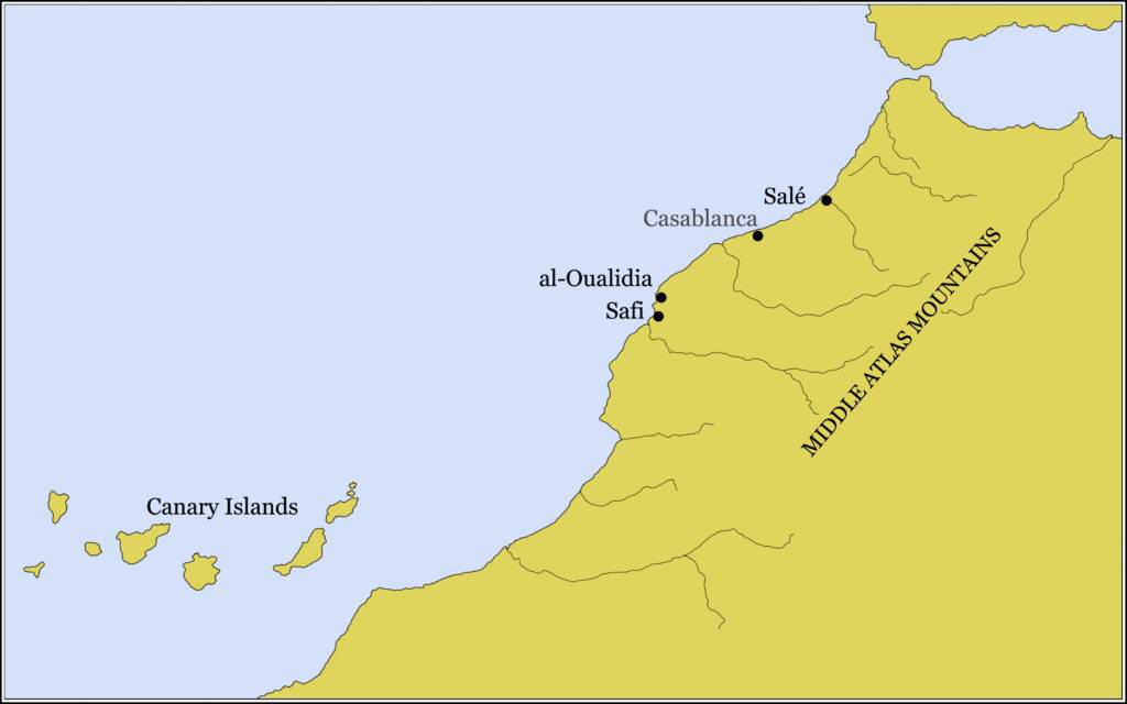
One major problem he faced was that he had reliable control of only one port on the Atlantic coast of Morocco: Safi (see the map below). In 1621, he conceived the idea of creating an entirely new port in Aier Lagoon, located at what is today al-Oualidia, on the Atlantic coast of Morocco between Casablanca and Safi. In order to create an entirely a new port out of nothing, he needed engineers. For these, he looked to the Dutch, with whom he had negotiated a treaty pledging mutual support (and mutual antagonism towards Spain) in January, 1610.
 Through intermediaries, he induced the States General of the Netherlands to send a special envoy to look into the practicality of his port project. That envoy was Albert Ruyl
In the end, Aier Lagoon proved unsuitable as a port, and the project collapsed amid some considerable acrimony. Ruyl, however, also went to Salé.
A quick refresher on Salé:
The city of Salé was a famous corsair capital during the seventeenth century. It was located on the south bank of the Bou Regreg River, which flows northwestwards from its headwaters in the Middle Atlas Mountains in the interior of Morocco and empties into the Atlantic Ocean about 170 miles (a little under 275 kilometers) south of the Strait of Gibraltar.
A large fortress—the Qasba—sat atop a promontory on the Bou Regreg’s south bank. The Qasba was the seat of government. Below it lay a newly constricted town of about 10,000 inhabitants. A sandbar lay across the mouth of the river, making it difficult for ships to enter the port (which was some distance upriver) except at high tide.
Albert Ruyl kept a detailed journal during his trip (which lasted from September 17, 1622, through July 19, 1624). This journal provides us with some of the most useful, and detailed, descriptions of Salé when the place was just embarking on its role as a major corsair capital.
The excerpts below from Ruyl’s journal—dating from December, 1622—provide a vivid sense of what it was like to deal with the Salé corsairs. They also reveal how much of an obstacle the sandbar that lay across the entrance to the Salé harbor was, especially in the winter, the time that Ruyl was there. Ruyl provides a surprising number of particulars, including estimates of the depths of the water over the sandbar, a detailed description of the Qasba itself, and an explanation of how the business side of the corsair enterprise in Salé was arranged.
Texts from the early seventeenth century can be confusing, so I have included explanatory notes where they seemed useful.
Sunday, December 4 — We saw the plateau of El-Ksar, which is near the river at El-Mamora. However, as the wind was south, it was impossible for us to reach the shore. At last, on the 6th of the same month, we fetched up about a mile to the south of the Salé roadstead, where we anchored in forty-five fathoms of water a mile and a half from the shore. We put out our ship’s boat and sent it to shore, but they came back without having found anyone to talk to.
Around midnight we had a west wind which obliged us to weigh anchor. The next day, we reached the roadstead with a northwest wind and, keeping the big tower in sight across from the Kasba, [1] we anchored on a clay bottom of twenty-five fathoms about a mile from the shore.
In the evening, a ship approached us along the shore and anchored within a cannon-shot of our vessel. We sent our ship’s boat over for news, but the other (it was a Moorish tartane [2]) proved hostile and fired on our craft. In return, our master gunner fired two shots from our cannon. At this, the Moors raised their anchor and took refuge against the shore.
Saturday, December 10 — We sent our two ship’s boats, with a letter to the Caïd [Governor of Salé], requesting of him that, if there were any Dutchmen held captive in Salé, he would kindly send them out to us, according to the alliance between His Majesty and Your Excellences. [3]
Arriving near the shore, our crewmen saw some Dutchmen who had been freed and were very eager to get to our ship. Since they could not cross because of the bar, our men launched the letter towards the shore, where it was picked up by the Moors, who carried it to the Kasba at once. They then reported, in response, that the Caïd was pleased with our arrival and wished to send us some refreshments from the King. [4] The Andalusians, [5] he added, were great friends of Your Eminences and his Excellency, [6] and tomorrow, if conditions were calm enough, he would send a zabra [7] out to us.
[1] The “big tower” was Hassan Tower, the minaret for the great mosque begun by the Almohad Sultan Abu Yusuf Yaʿqub al-Mansur at the end of the twelfth century. The mosque was never completed, and only the tower and a series of columns and the beginnings of foundation walls were constructed. At a height of 144 feet (44 meters), Hassan Tower would have been discernible from a fair distance out to sea and made a perfect navigation landmark. Ruyl’s ship clearly used it as such to position themselves before the “Kasba”—the Qasba, the fortress and seat of government on the promontory of the south bank of the Bu Regreg River, on which Salé was situated.
[2] A tartane (also spelled tartan) was a smallish ship, usually between 40-65 feet (12-20 meters) long, typically used for coastal trading or fishing. Tartanes had one or two masts rigged with either lateen sails or a combination lateen and square sails, often with a bowsprit and a foresail as well. They were much used by Salé corsairs because they were nimble sailers and their relatively small size and shallow draft made it easy for them to cross the bar into the Salé harbor.
[3] The term “His Majesty” here refers to Sultan Moulay Zaydan; the term “Your Excellences” refers to the members of the States General, the ruling body of the Republic of the Netherlands. The States General and Moulay Zaydan had signed a treaty in 1610. At this time, Salé was—nominally at least—under the control of Sultan Moulay Zaydan. Ruyl is addrsssing his report of events to the the States General.
[4] These “refreshments from the King” were known as mouna and were provided by the Sultan via a levy on the local population. Such mouna were largesse officially distributed to those traveling in the Sultan’s service or those he particularly wished to honor. Sultan Moulay Zaydan was not personally involved here, but the Caïd of the Kasbah would have offered such mouna refreshments as a calculated political move.
[5] The term “Andalusians” refers to Spanish expulsados, the people who had been expelled from Spain in the spasm of ethnic cleansing that occurred in 1609-1614 when something close to 300,000 Moriscos (descendants of Spanish Muslims) had been forcible removed from the Iberian Peninsula. Close to 15,000 of them eventually ended up in Salé and created the city on the Bou Regreg River’s south bank.
[6] The term “Your Eminences” here refers to the members of the States General; the term “his Excellency” seems here to refer to Maurits van Oranje (Maurice of Orange), known as the Prince of Orange, who was the stadtholder (head of state) of the Dutch Republic rather than to Sultan Moulay Zaydan.
[7] A zabra was a small sailing boat of Spanish origin, equipped both with oars and with one or two masts, often lateen rigged. Saletians used them to transport men and material across the sandbar, so their zabras were most likely no more than perhaps 20-25 feet (6-7.5 meters) long, with a shallow draft.
For more from the journal of Albert Ruyl, see Excerpts from the Journal of Albert Ruyl – Part 2 here in this blog.
__________
For those who may be interested…
The above excerpts from Albert Ruyl’s journal come from Henry de Castries, ed. Les sources inédites de l’histoire du Maroc, première série, dynastie saadienne : archives et bibliothèques des Pays-Bas, tome III (The Unpublished Sources of Moroccan History, First Series, Sa’adian Dynasty, volume 3), pp. 266-67. The translation into English is my own.
 The Travels of Reverend Ólafur Egilsson
The story of the Barbary corsair raid on Iceland in 1627
Amazon listing