(This post is a continuation of Salé, the Turbulent City – Parts 1, 2, & 3. If you haven’t done so already, it’s best to read those posts before continuing on here.)
When the Hornacheros arrived on the south bank of the Bou Regreg River, they must have been severely disappointed to discover that that this new home they had finally reached was a crumbling ruin. They were out of options, though, so they proceeded to rebuild. They chose to settle in Qasba (the ribāt fortress on the promontory overlooking the Atlantic), repairing the crumbling walls and constructing over 200 houses, all honeycombed tightly together.
The Hornacheros had been essentially an autonomous community back in Spain, so they were uniquely equipped to set themselves up in their new home. Soon—nobody knows quite how soon—they had a functioning self-ruling government going. They found themselves surrounded on all sides by locals who mistrusted them, however. Perhaps because of this, or perhaps because they simply had grand ambitions for the town they were founding, they sent out the word to other Spanish expulsados in Morocco that Salé was a good place to settle. They even helped pay travel expenses for this new batch of settlers.
As usual, it is difficult to come up with precise numbers, but it seems that a total of somewhere around 10,000 made the trip to Salé. To distinguish them from the Hornacheros, these folk are typically referred to as Andalusians—not because they came from what is now the comunidad autónoma of Andalusia in Spain, but because they came from al-Andalus.
There was no possible way for so many new people to crowd into the Qasba, and the Hornacheros no doubt had never intended to share their quarters anyway, so the newcomers set up outside the Qasba but inside the old walls built under the auspices of Ya’qub al-Mansur four centuries before (known as the Almohad walls, since Ya’qub al-Mansur was an Almohad Sultan).
There was already a town of sorts there, but it was little more than a cluster of buildings on the riverfront. The Andalusians spread out from that point, laying out streets and constructing dwellings, filling up a portion of the empty space within the Almohad walls. Eventually, they built a new protective wall for themselves, running from the riverfront to one of the original fortified gateways of the old Almohad wall.
The end result of all this expansion was that New Salé now consisted of two separate sections, each with its own distinct Morisco expulsado population.
The Qasba, with its 3,000 Hornacheros, was the seat of government. The Hornacheros had endured enormous hardship to arrive in Salé, and it is easy to sympathize with them, but they were in fact a hardnosed bunch. Back in Hornachos, they had lived as a sort of ruthlessly self-serving Cosa Nostra, robbing and murdering travelers, minting counterfeit coins, and bribing state officials. They had not enticed the Andalusians to settle there in order to create an egalitarian utopia. The new town, with its 10,000 or so inhabitants, was relegated to being a vassal state to the Qasba. This was trouble waiting to happen.
In the meantime, though, the town grew.
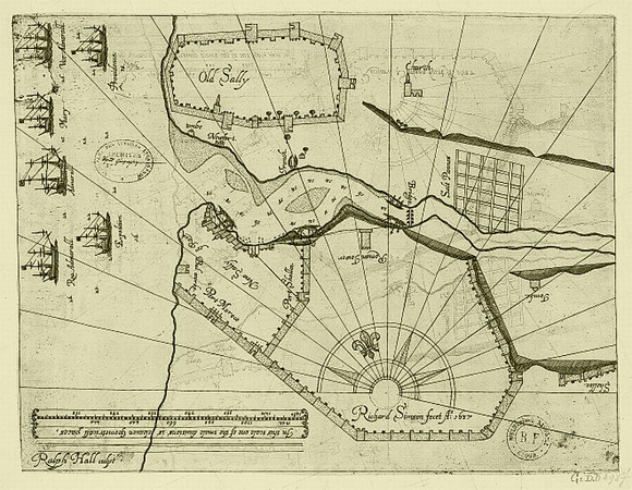
In the map at the top of this post (a map originally drawn in the 1630s), you can see Old Salé (“Old Sally”) on the north bank of the Bou Regreg River. On the south bank are the Qasba (the cluster of buildings on the promontory) and New Salé (“new Sally”) with its slightly dog-legged protective wall running from the river to the Almohad wall to the south. The map makes it appear as if “New Sally” is devoid of buildings. In fact, it was packed with them, for, remember, it held 10,000 inhabitants.
You can also see just how large a town Ya’qub al-Mansur, the Almohad Sultan, dreamed of: a settlement of something like 13,000 people fills no more than a quarter of the available space inside the Almohad walls. During the early seventeenth century, the rest of that space was empty (just as the map depicts), taken up with crops such as wheat, barley, beans, and grapes. In the 1630s, the New Salé vineyards could produce upwards of 200 tunns (a tunn was about 250 gallons) of wine annually—which no doubt confirmed all the darkest suspicions the pious teatotalling Muslim inhabitants of Old Salé harbored against the expulsado newcomers.
Notice, also, the sandbars in the river. Over the centuries, the Bou Regreg River had been—and still is—silting up. In the early seventeenth century, there were large, shifting sandbars across the river mouth where the river met the sea. At low tide, these sandbars were covered by not much more than a foot or two (half a meter of less) of water. Ships could only enter the harbor at high tide, when there was about 10 to 13 feet (3 – 4 meters) of water over the sandbars, depending on the state of the tide. These sandbars limited the size of ships the Salé corsairs could use.
The sandbars at the river’s mouth may have been a limitation, but they also proved to be a blessing. The large European warships that periodically arrived to attack Salé could not cross them to enter the harbor and so had to lob cannon fire at the town from a distance. Because the port was tucked up against New Salé on the south bank of the river, it was difficult for European ships out in the roadstead to get a direct line of fire on it. This meant that the port itself—and any ship moored at the docks there—was virtually immune from offshore cannon fire.
As you can also see from the map, the river had silted up in front of Old Salé, and there was no good spot for any sort of harbor there. On the south shore bordering New Salé, however, the water was about 15 to 18 feet (4.5 – 5.5 meters) deep, so once past the sandbars, ships could confidently approach the quays and unload their cargo—both human and otherwise.
The fact that Old Salé had no good harbor meant that they were unable to take advantage of the influx of pirates/corsairs and the wealth they brought in. This was a continuing source of friction between the two towns.
— § —
By the mid 1620’s, Salé (New Salé, that is) had become the premier corsair port of the Atlantic.
The town had been rebuilt and repopulated. The Hornacheros had financial resources (they had brought money with them from Spain) and access to manpower (both the Andalusians and the local inhabitants), and both expulsado groups were blisteringly eager for revenge against the Spanish, who had taken from them their homes, their young children, their livelihoods, and whatever original dreams and hopes they might once have had.
Salé’s position on the coast was ideal for a corsair base: far enough south of the Strait of Gibraltar—about 170 miles (275 kilometers)—to be beyond the reach of Spanish domination but still close enough to be a practicable location from which to launch raids against European shipping and coastlines.
So Salé had location, a sheltered harbor, financial resources, manpower, markets, and piratical expertise (brought in by English and Dutch pirates and renegades, and North African corsairs).
This chance combination of events and geography meant that Salé was in exactly the right place at exactly the right time to prosper.
And prosper it did.
So much so, that the Hornacheros began to think that they had everything they needed to become independent.
So they broke away from Sultan Moulay Zaydan and announced their existence as a free and independent republic.
To see how that went, see the next post in this series: Salé, the Turbulent City – Part 5.
 The Travels of Reverend Ólafur Egilsson
The story of the Barbary corsair raid on Iceland in 1627
Amazon listing