
(This post is a continuation of Salé, the Turbulent City – Part 1. If you haven’t done so already, it’s best to read that post before continuing on here.)
Salé became the corsair capital that it did, at the time that it did, in large part because of the Hornacheros.
A series of posts here in this blog back in November 2018 (in the Corsairs section) dealt with the Hornacheros in detail, so all we need to say of them here is that they were a group of Moriscos from the town of Hornachos (hence their name), in what is now middle-southwestern Spain, near the border with Portugal. Like tens of thousands of other Moriscos, they were forcibly expelled from Spain in 1610 and ended up in Morocco, homeless.
Sultan Moulay Zaydan was in the middle of a violent struggle with his brother at the time, and he desperately needed allies. He viewed the Hornacheros as exactly the sort of allies he was looking for: foreigners who had no local alliances.
Moulay Zaydan was trying to hold on to Salé, which was a vital port, but he didn’t have the manpower needed to garrison it. So he offered Salé as a new home to the Hornacheros—if, in return, they swore loyalty to him.
It was too good an offer to pass up, and so the Hornacheros—about 3,000 of them, men women and some children (many of their young children had been taken from them by the Spanish)—swore to support Moulay Zaydan, packed up their belongings, and made the trek to Salé.
The inhabitants of Old Salé—the town on the north bank of the Bou Regreg River—rejected these newcomers when they arrived. Old Salé had a long tradition of being a religious center and an abode of holy men. Its pious inhabitants viewed the Hornacheros as heretical: they dressed in strange ways, their Arabic was strangely accented and full of odd words, and, since they had come from a Christian country, the genuineness of their Muslim faith was doubtful.
It was made very clear to the Hornacheros that they were not welcome in Old Salé. So they set up in New Salé—which had likely been Moulay Zaydan’s plan all along anyway.
When the Hornacheros arrived at the settlement on the south bank of the Bou Regreg, they found the place in ruins. An English merchant who was in Morocco in the 1630s described what it was like there in the late 1500s:
“It was in a manner desolate, abandoned by the Larbyes [local inhabitants] because of wild beasts, for the ruinous castle had become a receptacle for lions, which there bred and terrified the poor peasants, so that they left the place and dwelt in doars [tents] in the open fields, less commodious but more secure.”
It’s not clear whether the Hornacheros actually had to chase off denning lions in order to make a home for themselves, but they certainly had to do some major rebuilding.
The “ruinous castle” the English merchant mentions was a fortress on the edge of the Atlantic. The Hornacheros chose to settle in this fortress, which became known as the Qasba (from Arabic al-qasaba, meaning “the town center” and also “the fortress”).
The south bank of the Bou Regreg where it meets the Atlantic consists of a rocky promontory almost 100 feet (30 meters) high. It is a perfect spot to place a defensive fortification and was used as the site of a ribāt—a fortified, garrisoned fortress—early in the twelfth century. At the end of that century, Abu Yusuf Ya’qub al-Mansur, an Almohad Sultan—the Almohads being one of the various dynasties that, over the centuries, ruled al-Andalus (Islamic Spain) and North Africa—began an ambitious building scheme there.
Yaʿqub al-Mansur re-named the place Ribāt al-Fath (Citadel of Conquest) and intended to make it his new capital city and to use it as a major base from which to prosecute the holy war against the infidel Spaniards.
His death (in 1199, at the age of fifty-nine) put an abrupt end to it all.
Nevertheless, a lot was still accomplished: the fortress on the promontory was enlarged and strengthened, a large perimeter wall was constructed to enclose the city-to-be, an aqueduct to bring in fresh water was built, and a grand mosque was begun, a mosque that would have been one of the largest (perhaps even the largest) in the world at that time if it had been completed.
The city walls—built using innumerable slaves as a labor force—were a thoroughly impressive accomplishment, extending over three miles (about 5 kilometers) in total , averaging 8 feet (2.5 meters) in thickness and 25 feet (7.5 meters) high. But the city that was supposed to fill the space inside those walls was never built. Of the mosque, only the great tower of the minaret—known as Hassan Tower, 144 feet (44 meters) tall—and a series of columns and barely-begun foundation walls were left remaining. (Astoundingly enough, both Hassan Tower and the Almohad walls can still be seen in Rabat today—see the photos at the end of this post for images of them and of the modern Qasba on the promontory.)
During the centuries after Yaʿqub al-Mansur’s death, Ribāt al-Fath fell into decay. The population dwindled. Lions took up residence.
In the early 1500s, Leo Africanus observed that the area in and around the Qasba had only two or three streets with a few forlorn shops on them. The large and imposing perimeter walls enclosed mostly fallow fields. The inhabitants lived in constant fear of attack by the Portuguese, who by then were expanding into the South Atlantic. Leo Africanus was moved to close his description of the place with the following: “Comparing the inhabitants’ former felicity with the present conditions into which they are fallen, I cannot but greatly lament their miserable case.”
Such was the state of things when the Hornacheros took up residence.
The image at the top of this post shows Salé as it was when the Hornacheros first arrived. The view is of Salé as seen from the west, from the sea. On the left is Old Salé on the north bank of the Bou Regreg River. On the other side—the south side—of the river are the Qasba on the promontory and the Almohad walls. Notice how empty the space they enclose is. At the distant end of the enclosed space, you can see Hassan Tower.
To find out how events enabled the Hornacheros to rebuild the ruins and create not only a new town but also a renowned corsair capital, and then an independent republic free from Moulay Zaydan’s rule, see the next post in this series: Salé, the Turbulent City – Part 3.
For those who may be interested…
— The quote by the English merchant about lions inhabiting the “ruinous castle” can be found in Les sources inédites de l’histoire du Maroc – première série, archives et bibliothèques d’Angleterre, tome III, (The Unpublished Sources of Moroccan History – First Series, Archives and Libraries of England, Volume 3) edited by Pierre de Cenival and Philippe de Cossé Brissac, p. 475. There were lions in Morocco (Barbary lions, also known as Atlas or North African lions) for a very long time. The Romans trapped them for the gladiatorial games in the Colosseum in Rome. As with many wild predators, however, human settlement tended to displaced them. It is unlikely that the ribāt fortress, which, though depopulated, was never fully emptied of inhabitants, ever served as an actual lions’ den. However, the English merchant’s anecdote is an indication of just how desolate the place must have looked at some point in order to spawn such a story.
— The Qasba, the fortress overlooking the Atlantic on the promontory on the south bank of the Bou Regreg River, started life as a ribāt. The ribāt system was in place throughout the Muslim world for a long time, from the shores along the coastal frontier of Palestine in the east, to the Atlantic coast of Morocco in the west. It consisted of a series of fortresses whose function was to defend the borders of the dâr al-Islâm (the abode of Islam) against incursions by infidel Christians. Ribāts were more than just forts, though. Since the battle in defense of Islam was seen as a holy war, they functioned as collection centers for militia volunteers (murabitun) but also as religious centers attracting scholars and holy men.
— Joannes Leo Africanus (John, the Lion of Africa) was born in the Muslim Emirate of Granada, in southern Spain somewhere around 1485 (opinions differ) and died, perhaps in Europe, perhaps in the Maghreb (again, opinions differ), around 1555. He is also alternatively known as Giovanni Leone, Jean d’Afrique, Yuhanna al-Asad al-Gharnati, al-Ḥasan ibn Muḥammad al-Wazzan al-Zayyati al-Fasi, or just al-Fasi.
His family emigrated from Granada to Fez, Morocco, where he received a sophisticated university education. As young man, he participated in a variety of commercial and diplomatic missions that allowed him to travel widely throughout North Africa. In 1518, while returning from one of these missions, he was captured by Christian corsairs. Because of his native intelligence and obvious education, he ended up before the Pope in Rome, where he eventually converted to Christianity, learned Italian and Latin, and was given his freedom.
Sometime around 1526, he completed the manuscript of a comprehensive work in which he described the history/geography of the whole of North Africa. In 1550, this was published in Italian under the title Della descrittione dell’Africa et delle cose notabili che iui sono, per Giovan Lioni Africano (A Description of Africa and the Notable Things There, by John, Lion of African). In 1556, Latin and French translations were published. In 1600, an English translation appeared. Leo’s work was hugely influential and widely read, and remained, for several centuries, the most important source of detail about North Africa available to European readers.
The quote about Salé is taken from a reprint of the 1600 English edition: A Geographical Historie of Africa, written in Arabicke and Italian. Before which is prefixed a generall description of Africa, and a particular treatise of all the lands undescribed, translated from the original by John Pory, Vol. II, Book 3, p. 408.
— The image of pre-Hornachero Salé that accompanies this post is taken from Civitates orbis terrarium (Cities of the Terrestrial Globe), a marvelous book (actually a series of six volumes published between 1572 and 1617) containing over 500 bird’s-eye views and maps of cities from all over the then-known world. There are several full color facsimile editions available today at quite reasonable prices.
— Below are some photos of modern-day Rabat.
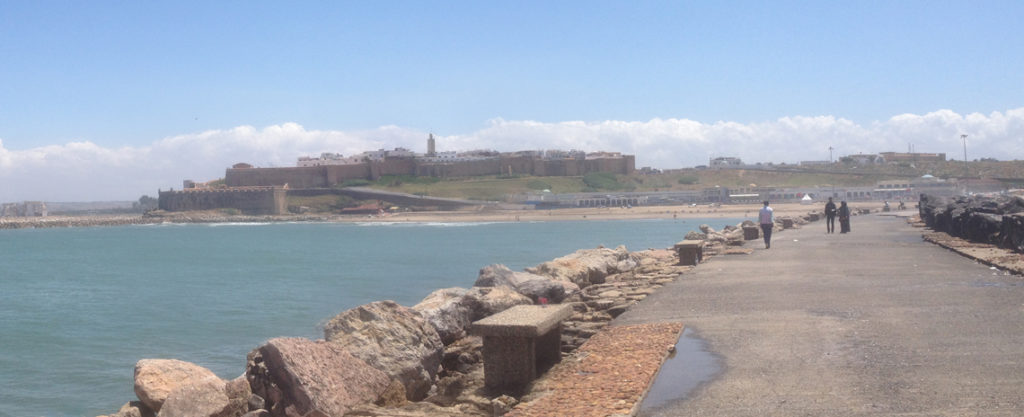
The Qasba as seen from the sea.
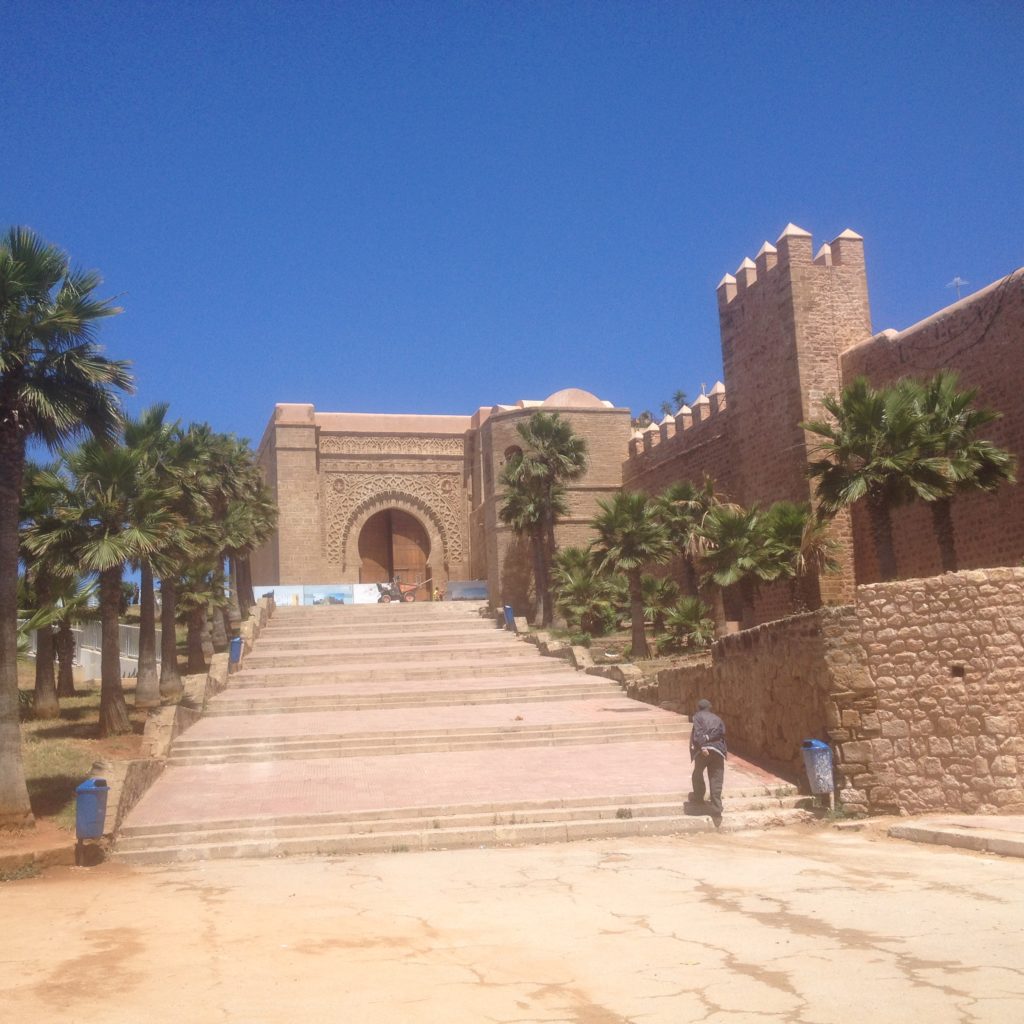
The entrance to the Qasba.
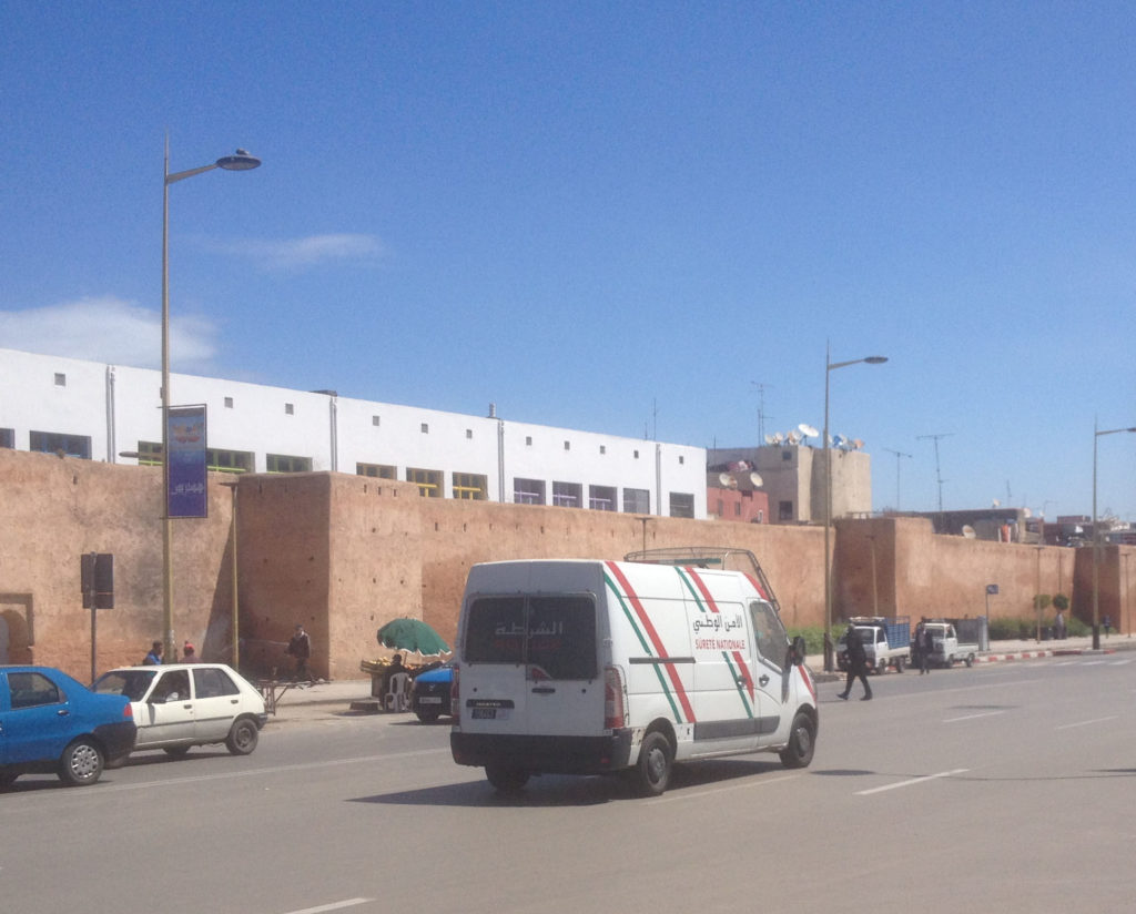
The old Almohad city walls.
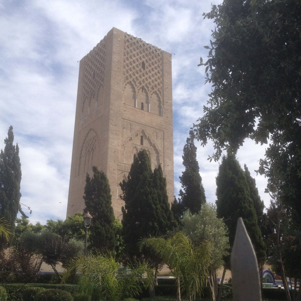
Hassan Tower.
 The Travels of Reverend Ólafur Egilsson
The story of the Barbary corsair raid on Iceland in 1627
Amazon listing