This week we continue the series of posts about Algiers, describing what the experience would have been like for European captives who were brought into the city. Last week, we looked at what arriving in Algiers was like for the captives brought there. This week we look at the city itself.
European cities in the seventeenth century had their crowded slums, but they also had open squares and wide thoroughfares—and sky. Algiers was a very different sort of place.
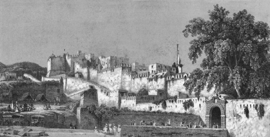
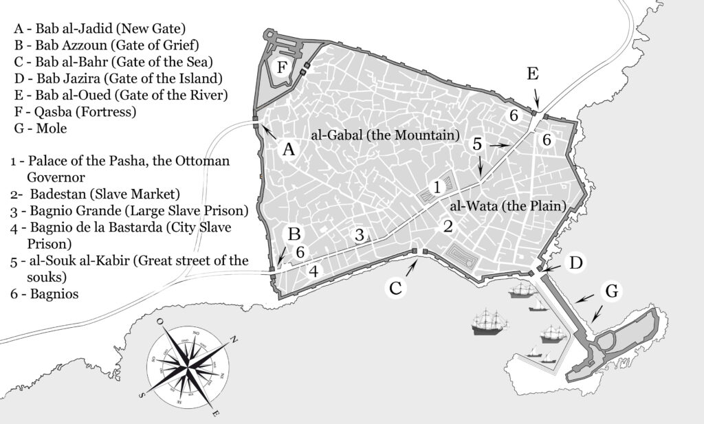
The city was divided into two sections: a lower portion, known as al-Wata (the Plain), containing the public buildings and the commercial, administrative, and military sectors, and an upper portion, known as al-Gabal (the Mountain), containing private dwellings, tightly packed with a myriad of individual houses. At the top of al-Gabal sat al-Qasaba (the Qasba, i.e., the Fortress), enclosed by its own walls. (See the map of Algiers below for the locations of these places.)
These three sections together formed a single municipal entity, bounded by an encircling, defensive wall studded with towers and ringed by a dry moat (which, in the early seventeenth century was mostly filled with refuse). The whole place was not much more than about three square kilometers in area.
A series of gates set into the wall gave access to and from the city. Roads from the main gates converged in the center of al-Wata. There was only one genuine thoroughfare: al-Souk al-Kabir (the Great Street of the Souk). About 30 feet (9 meters) wide and lined with souks (markets), this street transected the city, running through al-Wata parallel with the waterfront, connecting the Bab al-Oued (the Gate of the River) at the northern end and the Bab Azzoun (the Gate of Grief) at the southern. (See the map of Algiers above for these places.)
Most of the city, though, was a maze of narrow, twisty alleyways. Many buildings were constructed with their second floors overhanging the alleys, cutting off the light, so the place had a dim, underground feel. And it was cramped. Here is one European observer’s description of the streets:
Neither a horseman nor two people walking side by side could pass through them easily. The entire city is so dense, and the houses so close to each other, that it all seems like a very tight pine cone… Barring the Great Street of the Souk, no other street can be found that is straight or well ordered… And because the houses are so close and the streets so narrow, one could almost walk the whole city via the rooftops.[1]
The American Consul in Algiers in the 1790s, had this to say in a letter to his wife (the city had apparently changed little over time):
Properly speaking, there are no streets, but only little dark alleys which run crosswise and zig-zag among an enormous heap of houses, thrown together without order and without number. It needs a long residence before being able to walk a hundred steps in this labyrinth without losing one’s self.[2]
This dim warren of alleyways and passages was a daunting place for those unfamiliar with it. An Italian captive who was brought to Algiers in the early 1800s, had this to say:
I always felt a secret horror in walking through the narrow, dark, and filthy streets of this shocking city. The heart is oppressed, and the very soul shut up, as it were, in its tortuous windings: breathing itself was attended with difficulty and pain. [3]
——
After they had been disembarked from the corsair ships, captives were herded up from the harbor, through a maze of narrow little streets in a victory parade, with the captain of the expedition marching proudly in the lead, flaunting his success before rowdy, appreciative crowds that clogged the route. The captives in his wake, prodded onwards by their guards, must have trudged along apprehensively, huddling together as best they could for safety.
They would all surely have felt a horror similar to Pananti’s, finding themselves herded through such a claustrophobic and disorienting warren of alleyways and close-set buildings, struggling to get a solid breath in the close, hot air, surrounded by ogling crowds—with no clear understanding of what was to become of them in this terrible place.
It must have felt like they were being driven into the outskirts of Hell itself.
For the next installment of this series of posts on Algiers, see the next post here in this blog.
____________________
[1] Maria Antonia Garcés & Diana De Armas, An Early Modern Dialogue with Islam: Antonio de Sosa’s Topography of Algiers (1612), p. 117. This book is a translation of the first book of Antonio de Sosa’s Topographia, e historia general de Argel (Topography and General History of Algiers), first published in 1612.
[2] Charles Burr Todd, ed., Life and letters of Joel Barlow, p. 126.
[3] Filippo Pananti, Narrative of a Residence in Algiers, pp. 68-69. This book was originally publish in 1818.
 The Travels of Reverend Ólafur Egilsson
The story of the Barbary corsair raid on Iceland in 1627
Amazon listing